Driving Directions
By Wally Glenn
This guide is a dynamic document that gets updated every time information on the Web site is updated. It is designed to be printed out and taken with you on the trip.
If you find it useful and you use it, buy me a frosty beverage next time you see me.
Cities
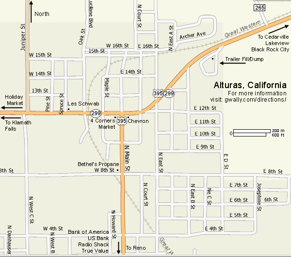
Alturas, CA
Alturas (pop. 3,200) is the end of the line when it comes to civilization. It is the county seat and the center for commerce for the surrounding area. You can get gas in Cedarville, but this is the last town with grocery stores, banks and such. If you need cash, water, groceries, gas, anything, get it here or you are on your own. Alturas, rolls up and goes to sleep after dark and Cedarville turns in even earlier.
If you forget anything you desperately need, Alturas is the last place you might be able to find it and the town is over 107 miles away (about 3 hours) from the Gerlach.
Burner Recommendations:
Alturas Chevron
This is a nice place to tank up. It's open from 5 AM - 2 AM most of the year and expands it's hours a bit to accommodate the crush of visitors around Labor Day.
The parking lot is usually full of Burners. It's a great place to meet others heading to BRC. Even if the store is closed, the pumps take credit/debit cards.
(530) 233-5114
4 Corners Market
1077 N Main St (CA-299 & US-395) Alturas, CA
One of the best last major food/supplies pit stops is the 4 Corners Market. It's right across the street from the Chevron. The Owner is a really cool fella who doesn't mind letting folks use his hose to top off or fill up their water jugs (if you ask nice).
(530) 233-3822
Holiday Market
1200 W 12th St (CA-299) Alturas, CA
A nice place to shop as well.
(530) 233-3655
Wagon Wheel Cafe
This is your typical diner with an attached motel. The food is very good food and friendly service.
Alturas Chamber of Commerce
They have a list of all of the businesses in Alturas you might need at:
alturaschamber.org/businesses.htm
Map of Alturas
Mini Yellow Pages
Holiday Quality Foods
(530) 233-3655
1200 W 12th St, Alturas, CA 96101
holidayfoods.com
Les Schwab Tire Ctr
(530) 233-3623
1201 Spruce St, Alturas, CA 96101
Wagon Wheel Restaurant
(530) 233-5166
308 W 12th St, Alturas, CA 96101
Cedarville, CA
Cedarville (pop. 1,100) is the last town you will drive through that has any semblence of being what can be considered a town. There is an gas station, two small stores, a burger stand, a restaurant, some motels and not much else. Eagleville has a very tiny store, a post office and no other establishments of any kind.
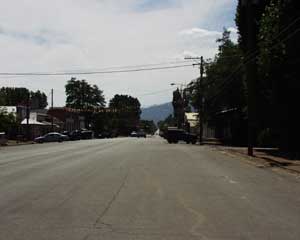
It's a good place to stop and have a bite to eat at Susan's Frosty. The service is not fast, but the burgers are good. While you wait, head across the street to the Pages Grocery Store and pick up any last minute supplies you might need. They have a lot of camping odds and ends.
There is not a single gas station of any kind between Cedarville and Gerlach, a stretch of 97 miles. Outside of the small store and post office in Eagleville, there is literally, nothing at all along this stretch of road.
Once you arrive in Cedarville, it is a great idea to check your water, tires and oil and top of your gas tank with the most expensive gas of the journey at the surliest gas station I have ever visited. The pass you will have crossed is 6305' and can be quite a chore for any vehicle. It's also 97 miles to the next service station. The gas station pumps do not work after hours and the station closes by either 6PM or 10 PM. If you don't need to stop for gas, then avoid these jerks.
2008 Update
CEDARVILLE GAS IS NOT CLOSED!
OK, make up your stinking minds. First it was run by Crazy Gar, then it was supposed to be run by some nice couple, then I was told it was closed, now it's open and there's a big sign that says "Closed by Wally".
The station is now open and people I trust told me its now being run by a nice couple.
There is a dearth of gas stations along the route and I recommend you fill up in Alturas, then top off in Cedarville if you have to. I highly recommend refilling in Gerlach or better yet at the Empire Store, a long-time Burner Friendly establishment, in case gas is not available when the event is over.
Burner Recommendations:
Food
Susan's Frosty - Burner Recommended!!
610 Main street
Cedarville, CA
(530) 279-6284
Mini Yellow Pages:
Country Hearth
501 Main street
Cedarville, CA
(530) 279-3354
Desert Deli & Pizza
551 Main street
Cedarville, CA
(530) 279-2280
Golden Bar & Restaurant
575 Main street
Cedarville, CA
(530) 279-2202
Tumbleweed Cafe
415 Main street
Cedarville, CA
(530) 279-6363
Valley Service Station
CLOSED!!!
601 Main street
Cedarville, CA
(530) 279-6241
Lodging
Cedarville Motel
State Route 299
West Cedarville, CA
(530) 279-2161
Drew Hotel
581 Main street
Cedarville, CA
(530) 279-2423
Sunrise Motel
State Route 299
West Cedarville, CA
(530) 279-2161
Pages Market
(530) 279-2626
488 Main St, Cedarville, CA 96104
Eagleville, CA
15 miles south of Cedarville, you will pass through the town of Eagleville. It is a nice, quiet town where it's past seems to have been it's highpoint. The only thing left is a post office, a very small store, a graveyard and a few buildings that could have been storefronts at one time, but now look very closed. It is has a nice, quiet overgrown feeling to it.
I have never been to the store due to my hours and it's hours never really syncing up, but if someone stops by, give me a trip report.
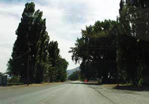
This is the last town of any sort you will pass through until Gerlach, some 75 miles to the south. Other than a few houses south of town, and a few near Gerlach, there is no signs of human activity. Just a windy, dangerous, undermaintained roads cutting through some beautiful, but very arid country.
Burner Recommendations:
Stop and enjoy the peace.
Google Map of Eagleville
Empire, NV
Empire (pop. Tiny) truly is a company town. US Gypsum, owns the entire town. It exists to house the workers at the factory, which produces around 80% of the gypsum board (drywall) in the US.
 photo by Taz. |
The only real reason to visit Empire is for the store. It is the only store within 50 miles and is an official retail outlet for Burning Man merchandise.
Well there is a 9 hole golf course, but I have never been able to find out what the green fees run.
Mini-Yellow Pages
Empire Store & Gas
61505 Highway 447, Empire, NV
(775) 557-2311
Black Rock Mini-Storage
61605 Highway 447, Empire, NV
5x10x9 storage runs $300/yr.
(775) 557-2608
Google Map of Empire
Gerlach, NV
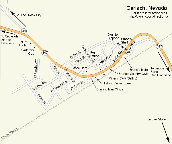
Gerlach (pop. 450) has one elementary / high school, one post office, one propane distributor, one gas station, one motel, 2 bars and that's it. We cannot list much in the way of information because there is hardly anything there. Burning Man maintains an office in town. The nearest grocery store is in Empire, which is 7 miles south of Gerlach.
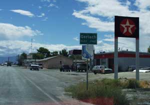
The gas station is on the south end of town with an additional gas station located in Empire. The gasoline prices are typically higher than anything you will be expecting. If you need to gas up for your return journey North, we recommend you gas up before you hit Black Rock City. The reason is that lines at the two pump gas station on the Sunday or Monday after the burn can be 30 minutes or longer.
If you plan on eating, Bruno's Country Club is the only restaurant within 90 miles. Bruno closes his doors promptly at 8:30 and if you are late, too bad. His bar is open as late as there are patrons, but he doesn't serve food in the bar. Next door is The Miners Club. It is a very nice place to spend time as well.
Mini-Yellow Pages
Bruno's Country Club & Motel
445 Main Street, Gerlach, NV
(775) 557-2220
Bruno's Texaco
565 Main Street, Gerlach, NV
(775) 557-2272
Granite Propane
480 Aspen Way, Gerlach, NV
(775) 557-2361
US Post Office
345 E Sunset BLVD, Gerlach, NV
(775) 557-2333
Miner's Club
4-- Main Street, Gerlach, NV
Planet X Pottery
8100 Highway 447, Gerlach, NV
(775) 557-2500
Map of Gerlach
Klamath Falls, OR
Klamath Falls (pop. 17,700) is the only town between Bend and Reno that has a population greater than it's altitude.
It is a great place to pick up groceries, construction supplies and other last minute supplies you might need. It has a branch of most regional banks and is the last town that will have all of them. It has a very large Fred Meyer, a Safeway, an Albertsons, almost anything you might need as long as it isn't too specialized. If you can't find it in Klamath Flalls, you will not find it anywhere further down the road towards Gerlach.
If you happen to be bringing large water barrels or other containers, we have found that the Fred Meyer store is very helpful and will allow you to fill up from their garden hose. After all, why would they think of stopping you when you also pick up a few hundred dollars in groceries and hardware?
One important thing to remember is that Klamath Falls is not a 24 hour town. The Fred Meyer is open from 7AM to 11PM daily. That goes for every other grocer in town. So if you happen to be going through Klamath Falls at 2:00 AM, the only thing open is a Denny's. It is, by the way, the last Denny's you will see on your journey.
Burner Recommendations
For folks coming from the north, in Merrill, Oregon (Just above the CA
Border) is a great greasy spoon hamburger joint called the Polar Bear. In a
classic building from the 1950s, you can get great old-fashioned burgers,
real milkshakes and other goodies...a great pit stop right out of the
1950's. They have a drive-up window, but you should go inside and make sure
to leave a Biz card on their wall (and look for one from a burner from South
Africa who went through with me in 2002).
Polar Bear
231 W Front St, Merrill, OR 97633
(541) 798-5724
Pixie's Gas
27600 Highway 97 N, Chiloquin, OR 97624
(541) 783-3933
Google Map of Klamath Falls
La Pine, OR
La Pine is a rural community located in southern Deschutes County near the Newberry Volcanic National Monument and Paulina Peak, home of East Lake and Paulina Lake (Where the state record Brown Trout was found) The recreation rich Cascade Lakes region of Central Oregon surrounds La Pine. There is abundant fishing, hiking and boating at any one of the many nearby lakes in the summer.
It is a growing town that just got it's first stop light. Woo!
La Pine is the last place for 24 hour gas until you reach Klamath Falls to the south or Alturas if heading east. When I drove through after 10:00 PM in July, 2005, the only open stations were at the north end of town. We recommend that if you are driving at night to fully tank up before you pass this town. It's best to have a full tank of gas before heading down OR-31 and if you have any other vehicle problems, this is the best place to find a solution for over 100 miles.
Sentry Market is open from 7am to 10pm.
Lakeview, OR
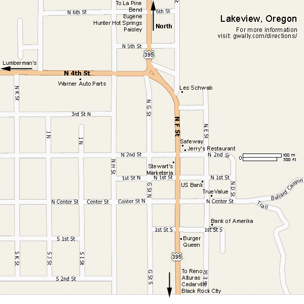
Ah yes, lovely Lakeview, Oregon. It's the county seat for Lake County (pop. 2,500) and since it is at an elevation of 4,820 feet, it claims to be the tallest town in Oregon. It's name comes from the fact that way back when it was established in 1878, you could clearly see Goose Lake, a large body of water south of town. This is also home to Old Perpetual, a geyser located at Hunters Resort which erupts boiling water into the air about once a minute. The town also has a fondness for really tall signs featuring cowboys. Including a rather odd one at the Safeway.
The town seems pleasant enough, but the entire town is closed by 10:00 PM. At last check no gas stations are open 24 hours. However, the Chevron in Alturas, CA does take Credit/Debit cards after hours.
Burner Recommendations:
Lakeview Safeway
Nice folks run this place. Lots of Burners come through.
244 N F St, Lakeview, OR
(541) 947-2324
Stewart's Marketeria
Across the street from Safeway is a similar sized market. It has low ceilings, low prices and interesting selections. It has that pleasant feel of a non-chain store. Stop in and check it out.
119 N F St, Lakeview, OR
(541) 947-2165
Jerry's Restaurant
Burger Queen might be tempting, but Jerry's serves good food and although they seem a bit wary of Burners, they have great prices. It's right next to Stewarts and Safeway.
508 N 2nd St, Lakeview, OR
(541) 947-2600
Les Schwab Tire Center
If you have any tire questions or problems, go to Les Schwab. They have great prices, wonderful service and integrity.
422 North F St, Lakeview, OR 97630
(541) 947-3388
Map of Lakeview
Nixon, NV
It's a town on the Paiute Indian Reservation. It's Police Department makes all of it's money on speeding tickets and Burning Man is payday. Worse, you have to pay the tickets on the spot. If you don't have the cash, I guess they impound your car. This is not a friendly town.
All I can say is drive 5 MPH BELOW the speed limit and be very careful you stay well below the speed limit. Seriously, this is the worst place for tickets in the entire area.
As a punishment and as a caution, please do not stop for any reason in Nixon. Don't stop for gas, don't stop for food, don't stop at all. Just drive through below the speed limit and deny them any revenue. Because if you stop, they might roll up and just investigate your car, which could lead to another ticket.
In 2007, The Payute's finished a very strange road "improvement" on the highway about 14 miles north of Nixon between Empire and Nixon. It is just after you leave the reservation for the SECOND time.
(You are in the reservation as you go around the end of Pyramid lake, then you leave it for a few miles right after all the sand dunes; then you enter it again for a few miles.)
Evidently they are planning on stopping a lot of cars here because they have paved a pull-off that is 4 lanes wide and long enough for 4 or so semi trailers. Do you need any more proof they are really looking at you as a revenue source?
Please watch for any sudden drop in speed signs in this area. It sounds like they will be springing a speed trap on people.
Paisley, OR
It is home to the annual mosquito festival in late July. It's a small town, but they seem to be friendly enough, so we have mentioned them here.
Burner Recommendations:
Paisley Mercantile
"The Merch" has most items you find in a general store, plus it is the outlet for liquor in the area and they are nice people. Wally recommends to eat at the place next door.
(541) 943-3110
Pioneer Saloon
Great burgers, great decor, nice people
Summer Lake Hot Springs
A great place to soak. Friendly people. Visit the Web page on our site.
OR-31
(503) 246-5145
Web site:
www.paisley.presys.com/chamber.html
Destinations
Cougar Hot Springs
Located at the Cougar resovoir (hence the name), in Rainbow, OR this is the most popular hot spring in the Eugene area. It's now a fee based spring, but the costs are $3.00 per person.
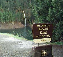
The source is the top pool which is around 112° F. There are several pools below this which get cooler they descend to a swimming hole. Most of the pools have bedrock with some gravel and sand at the bottom.
The hot springs are day use only.
Fees:
$3.00 per person.
Driving Directions:
From Eugene:
Rider Creek Arm of Cougar Reservoir and Terwilliger Hot Springs are 53.3 miles East of Eugene. From the intersection of I-5 and I-105/Highway 126 in Eugene, head east on Highway 126 to the end of the divided highway, 6.6 miles. Turn left onto Main Street, continuing on Highway 126, and drive to the Cougar Reservoir turnoff, Forest Road 19, 39.0 miles, between mileposts 45 and 46. Turn right and drive to a dam, 3.4 miles. Turn right at the dam to go around the west side of the reservoir to the parking lot near the hot springs trailhead, 4.3 miles.
From La Pine:
Head North on US-97 to US-20 (32 mi), then head west toward Salem (48 mi). Merge onto OR-126 and head east for 28.1 miles to Rainbow. Turn left onto the Mckenzie River Rd. Follow the signs.
Web site:
www.fs.fed.us/r6/willamette/recreation/cougar
hotsprings.gif)
Crater Lake
Just off US-97 between the Willamette Pass and Klamath Falls is Crater Lake. It's beautiful deep blue water and spectacular views has brought almost a half million visitors a year to this remote spot in Oregon. The deep blue of the water comes from it's amazing depth over 1900 feet.
For well over 100 years, people have come from all points of the globe to see this subtle, but beautiful place. It is the remnant of an ancient volcano crater. The rim is a circle more than 20 miles around and each point seems more beautiful than the last.
Crater Lake could be enjoyed as few hour detour or as a multi-day excursion. It is definitely worth checking out.
Fees:
This is a fee park.
Web site:
nps.gov/crla/
Nice Photos:
http://www.cs.uoregon.edu/research/paracomp/oregon/huge/crater.lake2.jpg
McCredie Hot Springs
The pool at McCredie is nice size and has a sandy bottom instead of rock. The water is Sulfury, shallow (chest deep sitting on your butt) and HOT HOT HOT.

There are several pools with varying temperatures. Some pools are muddy and nice. Not so muddy that you can't get out clean. Not too populated. The other three folks that were there were burners too, and sweet. Incidentally, none of us knew them or their camp, but they'd heard of sex kitchen.
Directions:
Head east on OR-58 past Oakridge. Just pass mile marker 45, pull into the big parking lot.
Fees:
No far, none. There could be a parking fee per car.
Web site:
oregonhotsprings.immunenet.com/mccredie.htm
Blue Pool Camp Site(nearby camp site)

Thanks to Amani Loutfy, Pope Phabulous for information.
Summer Lake Hot Springs
OK, what if we told you we found a faster route to Burning Man from Seattle and along the way was a really wonderful and cheap place to camp run by really nice people? You'd say wake up from the pipe dream, right?
Well the good news is that we have actually located such a place. It is such a great discovery we thought about keeping it secret, except then how would we run into all of our great friends we met on the Playa one more time?
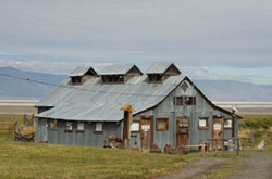
The place is called Summer Lake Hot Springs. It is located 45 minutes north of Lakeview, Oregon, just outside Paisley. The best news is that it is actually along a road that takes you to Burning Man faster than if you took the route via Klamath Falls.
The hot spring has been made into a bathhouse built in the 1920's. It has hundreds of signatures carved into the walls from visitors over the years. The owners really like the people they have met from Burning Man and they would like to encourage people to come and stop in on their way back from the Playa.
The pool is fed by a spring that delivers water at 113 degrees. It has a good flowrate and the water is not too hot or too laden with sulfur. Feel like taking an hour-long hot shower? Not a problem. The showers are 119 degrees and fed by a separate spring. If you feel like kicking back and showering for two hours, just bring your folding chair and relax. The shower is fed by a separate spring so you never have to worry about running out of hot water.
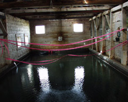
The cost is $6.00 a person per day which includes use of the hot springs. You can stay in the hot springs all night if you like, the owners simply ask that you keep food and drink out of the water and keep the noise down at night. Best of all, there is no noise from the surrounding area and the place is nearly vacant of people. It is truly a hidden gem of a location.
Directions:
10 miles north of Paisley, OR, located on OR-31.
Fees:
$6 a day
Web site:
www.summerlakehotsprings.com
Driving Routes
Mileage Calculator
This map resides at: gwally.com/directions/mileage.php
Route 1
Pros: Follows I-5 down to Eugene which is a familiar Freeway. Willammete Pass is spectacular. Klamath Falls and Alturas provide some sense of civilization lacking on the trek across Oregon on Route 2 & 3.
Cons: Commuter traffic can bog down the road between Vancouver, WA and Eugene, OR. Willamette is a steep pass. An accident can shut down the road.
Overview: This route takes you down I-5 along a fairly flat, familiar road. It's great if picking up friends and the driving time is about the same as the faster path. Willammete Pass on OR-58 is one of the most scenic spots I have ever seen in the Western United States. The drive across central Oregon is remote and beautiful. Crater Lake is along the route and a wonderful side trip.
Estimated route time & distance:
Seattle to Gerlach, NV
Distance: 700 mi.
Driving time: 18 hours
Seattle to Eugene, Oregon
Distance: 288 mi.
Driving time: 5 hours
I-5
From Seattle to Eugene, you will be on I-5 and most services you expect to find along an interstate corridor.
Eugene to Klamath Falls, Oregon
Distance: 168 mi.
Driving time: 4 hours
I-5, OR-58, US-97
From Eugene you will pass through the Willamette National Forest with breathtaking views and wonderful Douglas Firs. This is the last time on the journey you will see trees like this. From here on out the land becomes more arid as you go. Halfway down your journey along US-97, you run across Crater Lake. This is a worthy detour if you can make the time and it is during the day.
Klamath Falls to Alturas, CA
Distance: 100 mi.
Driving time: 2.5 hours
US-97, OR/CA 139, CA-299
Gas prices are on average 17 cents higher per gallon in California than Oregon. We highly recommend that you completely top off before leaving Klamath Falls. Klamath Falls is the largest town in the area and the only town that you will pass through that has a population higher than it's elevation.
A great place to stop is Pixie's Gas at 27600 Highway 97 N; Chiloquin, OR 97624; (541) 783-3933
Alturas, CA to Cedarville, CA
Distance: 23 mi.
Driving time: 40 minutes
US-395, CA-299, CA/NV-447
We highly recommend that you top off your tank in Alturas. We recommend the Alturas, Chevron because it is open late (not always 24 hrs, but the pumps take credit cards) and popular with Burners. This is also where you face the Cedarville Pass. It is 6305 ft and there is no other alternative. Check your water and if driving with a trailer, be courteous to other drivers going up the pass who may be able to pass you. If you ride your brakes going down the pass, they can easily overheat and catch fire. Instead, Downshift.
Cedarville, CA to Gerlach, NV
Distance: 85 mi.
Driving time: 2 hours
CA/NV-447
This is the most desolate stretch of the journey. The only business along the way between Cedarville and Gerlach is the small store and Post Office in Eagleville, Planet X Pottery a few miles outside of Gerlach and thats it. There is almost no houses and I do not know if the ones along the route are occupied or not. One mile before you reach Gerlach, there is a short road that allows you to cross directly to NV-34 and skip Gerlach entirely.
Gerlach, to Burning Man
Distance: 11 mi.
Driving time: 20 minutes
NV-447, NV-34
We can't emphasize this enough, when in Gerlach and the surrounding suburbs, drive belowthe speed limit. You will see more police officers in Gerlach than you saw during your entire journey. They have no problem writing tickets for any offense. However, it has been our experience that the officers will treat you with the same amount of respect that you show them. So our advice is to be courteous to the locals an participants alike. I hate to be preachy, but anything you do reflects on the festival as a whole.
Exodus
I like to encourage people to fuel up completely before entering the event. In 2012, we can expect 60,000 people braving Exodus and most of those will leave on Monday. Even if you left at 6:00am, you can expect a 4-8+ hour wait in line before you hit NV-34. It is very wise to consider fueling up your vehicle before you get to Burning Man. I personally recommend a stop at the Empire Store. However, if you hit Cedarville, perhaps consider purchasing an extra five gallons of fuel, just in case. Optimally, you would have enough fuel in your vehicle to make it to Burning Man, wait to get in, wait to leave and make it back to Cedarville and skip any gas lines at Bruno's or Empire Store.
Route 2
Pros: Follows I-5 down to Eugene which is a familiar Freeway. Willammete Pass is spectacular and nice hot springs.
Cons: Commuter traffic can bog down the road between Vancouver, WA and Eugene, OR. Willamette is a steep pass. An accident can shut down the road.
Overview: This route takes you down I-5 along a fairly flat, familiar road. It's great if picking up friends and the driving time is about the same as the faster path. Willammete Pass on OR-58 is one of the most scenic spots I have ever seen in the Western United States. The drive across central Oregon is remote and beautiful. Summer Lake Hot Springs in Paisley is a great meeting place for Burners along the way.
Estimated route time & distance:
Seattle to Gerlach, NV
Distance: 700 mi.
Driving time: 16.5 hours
Seattle to Eugene, Oregon
Distance: 288 mi.
Driving time: 5 hours
I-5
From Seattle to Eugene, you will be on I-5 and most services you expect to find along an interstate corridor.
Eugene to La Pine, Oregon
Distance: 121 mi.
Driving time: 3.5 hours
I-5, OR-58, US-97
From Eugene you will pass through the Willamette National Forest with breathtaking views and wonderful Douglas Firs. This is the last time on the journey you will see trees like this. From here on out the land becomes more arid as you go. I highly encourage you to tank up in La Pine, no matter what your fuel situation might be. There are no 24 hour gas stations for the rest of the journey. Although you can use a credit/debit card at the Alturas Chevron after hours.
La Pine to Lakeview, OR
Distance: 145 mi.
Driving time: 4.5 hours
US-97, OR-31, US-395
After fueling up in La Pine, you head east through Oregon on the second most desolate stretch of the trip. You pass through some wonderful country during the day and by night, well, have your windshield fluid topped off because you will pass through swarms of bugs that are unbelievable. Also, watch for animals on the roadway such as deers, cows and of course, skunks.
Lakeview, OR to Cedarville, CA
Distance: 65 mi.
Driving time: 2 hours
US-395, CA-299, CA-447
Gas prices are on average 17 cents higher per gallon in California than Oregon. We highly recommend that you completely top off before leaving Lakeview. There is one gas station south of town that closes around 10:00 PM and no other that is regularly open until Alturas. This is where you face the Cedarville Pass. It is 6305 ft and there is no other alternative. Check your water and if driving with a trailer, be courteous to other drivers going up the pass who may be able to pass you. If you ride your brakes going down the pass, they can easily overheat and catch fire. Instead, Downshift.
Cedarville, CA to Gerlach, NV
Distance: 83 mi.
Driving time: 2 hours
CA/NV-447
This is the most desolate stretch of the journey. The only business along the way between Cedarville and Gerlach is the small store and Post Office in Eagleville, Planet X Pottery a few miles outside of Gerlach and that's it. There is almost no houses and I do not know if the ones along the route are occupied or not. One mile before you reach Gerlach, there is a short road that allows you to cross directly to NV-34 and skip Gerlach entirely.
Gerlach, to Burning Man
Distance: 11 mi.
Driving time: 20 minutes
NV-447, NV-34
We can't emphasize this enough, when in Gerlach and the surrounding suburbs, drive below the speed limit. You will see more police officers in Gerlach than you saw during your entire journey. They have no problem writing tickets for any offense. However, it has been our experience that the officers will treat you with the same amount of respect that you show them. So our advice is to be courteous to the locals an participants alike. I hate to be preachy, but anything you do reflects on the festival as a whole.
Exodus
I like to encourage people to fuel up completely before entering the event. In 2012, we can expect 60,000 people braving Exodus and most of those will leave on Monday. Even if you left at 6:00am, you can expect a 4-8+ hour wait in line before you hit NV-34. It is very wise to consider fueling up your vehicle before you get to Burning Man. I personally recommend a stop at the Empire Store. However, if you hit Cedarville, perhaps consider purchasing an extra five gallons of fuel, just in case. Optimally, you would have enough fuel in your vehicle to make it to Burning Man, wait to get in, wait to leave and make it back to Cedarville and skip any gas lines at Bruno's or Empire Store.
Route 3
Pros: The fastest route, the least amount of mountain passes, no commuter traffic and nice hot springs.
Cons: Very few services between La Pine and Lakeview.
Overview: This route takes you off I-5 at Vancouver, WA and heads into rural country. You pass through some amazing scenic country and towns like Bend which have many of the same services you would find along I-5. The drive across central Oregon is remote and beautiful. Summer Lake Hot Springs in Paisley is a great meeting place for Burners along the way.
Estimated route time & distance:
Seattle to Gerlach, NV
Distance: 660 mi.
Driving time: 16 hours
Seattle to La Pine, OR
Distance: 360 mi.
Driving time: 7.5 hours
I-5, I-205, US-26, US-97
I highly encourage you to tank up in La Pine, no matter what your fuel situation might be. There are no 24 hour gas stations for the rest of the journey. Although you can use a credit/debit card at the Alturas Chevron after hours.
La Pine to Lakeview, OR
Distance: 145 mi.
Driving time: 4.5 hours
US-97, OR-31, US-395
After fueling up in La Pine, you head east through Oregon on the second most desolate stretch of the trip. You pass through some wonderful country during the day and by night, well, have your windshield fluid topped off because you will pass through swarms of bugs that are unbelievable. Also, watch for animals on the roadway such as deers, cows and of course, skunks.
Lakeview, OR to Cedarville, CA
Distance: 65 mi.
Driving time: 2 hours
US-395, CA-299, CA-447
Gas prices are on average 17 cents higher per gallon in California than Oregon. We highly recommend that you completely top off before leaving Lakeview. There is one gas station south of town that closes around 10:00 PM and no other that is regularly open until Alturas. This is where you face the Cedarville Pass. It is 6305 ft and there is no other alternative. Check your water and if driving with a trailer, be courteous to other drivers going up the pass who may be able to pass you. If you ride your brakes going down the pass, they can easily overheat and catch fire. Instead, Downshift.
Cedarville, CA to Gerlach, NV
Distance: 83 mi.
Driving time: 2 hours
CA/NV-447
This is the most desolate stretch of the journey. The only business along the way between Cedarville and Gerlach is the small store and Post Office in Eagleville, Planet X Pottery a few miles outside of Gerlach and that's it. There is almost no houses and I do not know if the ones along the route are occupied or not. One mile before you reach Gerlach, there is a short road that allows you to cross directly to NV-34 and skip Gerlach entirely.
Gerlach, to Burning Man
Distance: 11 mi.
Driving time: 20 minutes
NV-447, NV-34
We can't emphasize this enough, when in Gerlach and the surrounding suburbs, drive below the speed limit. You will see more police officers in Gerlach than you saw during your entire journey. They have no problem writing tickets for any offense. However, it has been our experience that the officers will treat you with the same amount of respect that you show them. So our advice is to be courteous to the locals an participants alike. I hate to be preachy, but anything you do reflects on the festival as a whole.
Exodus
I like to encourage people to fuel up completely before entering the event. In 2012, we can expect 60,000 people braving Exodus and most of those will leave on Monday. Even if you left at 6:00am, you can expect a 4-8+ hour wait in line before you hit NV-34. It is very wise to consider fueling up your vehicle before you get to Burning Man. I personally recommend a stop at the Empire Store. However, if you hit Cedarville, perhaps consider purchasing an extra five gallons of fuel, just in case. Optimally, you would have enough fuel in your vehicle to make it to Burning Man, wait to get in, wait to leave and make it back to Cedarville and skip any gas lines at Bruno's or Empire Store.
Route 4
Pros: Although not the shortest route, it is by far the fastest route with the least amount of traffic congestion. You skip all of I-5 and the commuter traffic between Everett, WA and Bend, Oregon. Very few mountain passes, no commuter traffic and nice hot springs.
Cons: Very few services between Columbia River and Madras and La Pine and Lakeview.
Overview: This route takes you over I-90 and completely skips I-5 and all of the traffic. If you are towing a trailer, taking a fully loaded vehicle or just nervous how your car will do on a pass, this is a great route to take since you hit your first pass right away and there are plenty of places to get vehicles serviced along the way. It's a great route for anyone in Western Washington, British Columbia and if you are already in Eastern Washington, it's much faster than taking US-395 south. The route through the Cascades is very scenic and the area south of Yakima through the Columbia Gorge is worthy of the journey. The drive across central Oregon is remote and beautiful. Summer Lake Hot Springs in Paisley is a great meeting place for Burners along the way.
Estimated route time & distance:
Seattle to Gerlach, NV
Distance: 685 mi.
Driving time: 13 hours
Seattle to Yakima, WA
Distance: 144 mi.
Driving time: 2.25 hours
I-90, US-97, I-82
Gas stations are open the entire route and just about any service you need is available all the way to Yakima. We strongly encourage you to tank up in Yakima, since there are no service stations between
Yakima to Biggs, OR
Distance: 83 mi.
Driving time: 1.5 hours
I-82, US-97
Take I-82/US-12 towards Richland, WA until you get to Exit 50, Toppenish, WA. There are no services between Toppenish and Goldendale, a distance of 51 miles. Biggs a small town full of truck stops on the Oregon side of the Columbia River. I recommend that if you need to top off fuel, this is the best place and possibly the only open place until you get to Madras (94 miles).
Biggs to La Pine, OR
Distance: 166 mi.
Driving time: 3 hours
US-97
Bend is the last city where you can find most services it is 100 miles from Biggs.
La Pine to Lakeview, OR
Distance: 145 mi.
Driving time: 4.5 hours
US-97, OR-31, US-395
After fueling up in La Pine, you head east through Oregon on the second most desolate stretch of the trip. You pass through some wonderful country during the day and by night, well, have your windshield fluid topped off because you will pass through swarms of bugs that are unbelievable. Also, watch for animals on the roadway such as deers, cows and of course, skunks.
Lakeview, OR to Cedarville, CA
Distance: 65 mi.
Driving time: 2 hours
US-395, CA-299, CA-447
Gas prices are on average 17 cents higher per gallon in California than Oregon. We highly recommend that you completely top off before leaving Lakeview. There is one gas station south of town that closes around 10:00 PM and no other that is regularly open until Alturas. This is where you face the Cedarville Pass. It is 6305 ft and there is no other alternative. Check your water and if driving with a trailer, be courteous to other drivers going up the pass who may be able to pass you. If you ride your brakes going down the pass, they can easily overheat and catch fire. Instead, Downshift.
Cedarville, CA to Gerlach, NV
Distance: 83 mi.
Driving time: 2 hours
CA/NV-447
This is the most desolate stretch of the journey. The only business along the way between Cedarville and Gerlach is the small store and Post Office in Eagleville, Planet X Pottery a few miles outside of Gerlach and thats it. There is almost no houses and I do not know if the ones along the route are occupied or not. One mile before you reach Gerlach, there is a short road that allows you to cross directly to NV-34 and skip Gerlach entirely.
Gerlach, to Burning Man
Distance: 11 mi.
Driving time: 20 minutes
NV-447, NV-34
We can't emphasize this enough, when in Gerlach and the surrounding suburbs, drive below the speed limit. You will see more police officers in Gerlach than you saw during your entire journey. They have no problem writing tickets for any offense. However, it has been our experience that the officers will treat you with the same amount of respect that you show them. So our advice is to be courteous to the locals an participants alike. I hate to be preachy, but anything you do reflects on the festival as a whole.
Exodus
I like to encourage people to fuel up completely before entering the event. In 2012, we can expect 60,000 people braving Exodus and most of those will leave on Monday. Even if you left at 6:00am, you can expect a 4-8+ hour wait in line before you hit NV-34. It is very wise to consider fueling up your vehicle before you get to Burning Man. I personally recommend a stop at the Empire Store. However, if you hit Cedarville, perhaps consider purchasing an extra five gallons of fuel, just in case. Optimally, you would have enough fuel in your vehicle to make it to Burning Man, wait to get in, wait to leave and make it back to Cedarville and skip any gas lines at Bruno's or Empire Store.
© Copyright 1998-2005 by Wally Glenn. All rights Reserved.
You may print this guide out and send it to your friends and use it to help you get to and from Black Rock City. Feel free to link to the guide, but since the information is constantly updated, please do not copy it to another Web site.
This page last updated at August 02, 2012 12:08 PM